 Envato elements stock image
IDAHO FALLS – As eastern Idaho gears up for the second wave of an extreme cold warning, the National Weather Service in Pocatello is forecasting heavy snow showers.
A winter storm warning is in effect from 11 a.m. Thursday to 5 p.m. Friday. It will impact the Mud Lake area, the eastern and southeastern and southeastern highlands and most of the Snake River Plain, along with the eastern Magic Valley and Wood River Valley.
Areas between Dubois and Monida Pass will be under a winter weather advisory during the same time period. The South Hills and Central Mountains are included in that.
RELATED | Extreme cold warning in effect Tuesday and Wednesday night
Temperatures ranging from -15 to -30 are expected Thursday morning while the extreme cold warning is in effect. Meteorologists are predicting initial snowfall on the western side of the state mid-morning Thursday with eastward movement impacting “almost everyone by 2 or 3 p.m.”
“Expect all snow with how cold temperatures are at the onset of this system. Since it’s another Pacific system, we actually warm gradually throughout the event, which leads to the potential for freezing rain. Best chance for freezing rain is from around Burley towards Pocatello after 8 p.m. Thursday,” a Wednesday afternoon weather briefing from the NWS says.
The chance of freezing rain is low. Snow will likely mix with rain on Friday afternoon as temperatures rise above freezing.
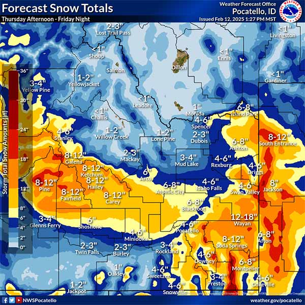
A graphic from the NWS shows anywhere from four to eight inches of snow throughout the U.S. 20-Interstate 15 corridor Thursday and Friday, with the brunt of it happening between 5 a.m. Thursday and 5 a.m. Friday.
Island Park, Ashton, Driggs and surrounding communities will see the most snow — three to four inches, according to the NWS. Two to three inches is likely from Rexburg to Pocatello.
Forecasters predict areas like Mackay, Arco, Mud Lake, Dubois, Spencer and Monida getting one to three inches overnight Thursday and early Friday.
“Winds will pick up Thursday afternoon with gusts of 25 to 35 mph in the eastern Magic Valley, South Hills, lower Snake River Plain and Southeastern Highlands, leading to travel impacts due to blowing and drifting snow,” the briefing says.
RELATED | Multiple slide-offs impacting traffic on Highway 20 north of Rigby
While the bulk of the storm is expected to wind down Friday afternoon and evening, more snow is on the way for the weekend.
“For the weekend, higher snow totals will be more focused on the Eastern Highlands,” meteorologists say.
Additional information is available in the graphics below.
For a complete forecast and live weather cams in your community, click here. The latest road conditions and closures can be found here.


 English (United States) ·